| Spratlys > News > Chinese News > July 2003 |
|
Category: @News @China |
|
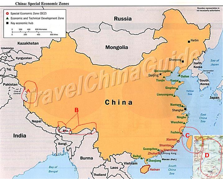
Map of China Correction Campaign on World Wide Web-- Correct the Wrong Maps of China on World Web SitesThe Correct Map of China The Map below roughly shows a correct Map of China. But not all maps of China on the World Wide Web are correct. Many are unfair to China.
Please pay attention to 4 parts in a map of China, as shown in the 4 circles in the
map above: B. Xizang Province's Southern part borders with India. This border dispute is the biggest land dispute all over the world. However, this part shown in most western maps is included in India and it is mainly the so called "Arunachal Pradesh" by the Indian. This part of area dispute is again created by the British during the British Indian time. The actual line of control now follows roughly as the MacMahon Line, which was again an illegal treaty between the British Indian governor and the Tibetan local government. Anyway the British didn't do their part they promised to the Tibetan local government in the treaty, so for long time the British didn't publish this line at all in their maps. After they left India the British published this map and India started to invade to Tibet land according to this map. This area is Chinese territory, it was invaded by the Indian from 1950s to 1962. However, China, for the consideration of world peace, has always been trying to seek a peaceful resolution of this dispute. The Indians also invaded and seized about 2000 sq km of land of China south of Yatng (Yadong) City of Tibet, bordering Sikkim (another Kingdom which was invaded by the Indians and was turned into an Indian state). Many respected map publishers in the world have put a "Chinese line of Claim" which is the real traditional border line between China and India in their maps published. However, many of the maps published on the internet just ignores this part and simply put this area under the India. This is not acceptable and is not respecting the fact at all. C. Taiwan Province is recognized as one part of China, however some maps colors Taiwan differently from the mainland China. D. Nanhai Zhudao (South Sea Islands), including the Dongsha Qundao (Pratas Islands), Xiasha Qundao (Paracel Islands), Nansha Qundao(Spratly Islands), and Zhongsha Qundao(Macclesfield Bank) and the adjacent seas has always been Chinese territory since as far as Han Dynasty (2000 years ago). The South China Sea countries invaded this area, especially the Nansha Islands and they seized most of the Islands for their security and economic purposes. Everyday they are stealling the oil from Chinese territory seas. China has always been seeking resolutions to this problem by using peaceful talks. China has no interest in other countries' land, but if one day when war breaks out because of Nansha Islands, China is just doing her own duty to protect its territory from other invaders. The Wrong but widely spreaded map of China Can you do anything to help to correct the wrong Chinese maps spreading on internet? Yes, you definitely can! When you see a wrong China map in internet, we hope you can write to their webmaster or the person in charge, tell them that their map is wrong. You can also tell them why their map is wrong. They can ignore one person's suggestion, they can ignore 10 people's suggestion, but they have to take it into consideration when thousands and thousands of us ask them to change. We can also form organizations to organize this campaign and continue this campaign until it succeeds. This is how the Koreans changed the name of "Sea of Japan" to "Sea of Japan (East Korea Sea)" on most maps published these days.
|
|
|
Copyright © 2003-2006 www.spratlys.org This page was last updated on 2006-04-06